24-day safari in Rwanda and Uganda
Discover the remarkable beauty within and surrounding Queen Elizabeth National Park.
Queen Elizabeth National Park is situated in western Uganda on the arid leeward side of the Rwenzori Mountain Range. The protected region is 1,978 square kilometers, which includes the Kyambura and Kigezi wildlife reserves located in the western segment of the Great East African Rift Valley.
The region encompasses a variety of physical formations, including volcanic fields featuring both freshwater and alkaline crater lakes. Additionally, there exist escarpments, expansive savanna plains, tropical forests, papyrus marshes, and the 45 sq.km Kazinga Channel, which links Lake George and Lake Edward. The watercourse is situated in the park, linking the two rift valley lakes, George and Edward.
Queen Elizabeth National Park
The varied ecosystem sustains a great biodiversity, encompassing 98 animal species, 8 primate species, including chimpanzees, and 612 bird species. Queen Elizabeth National Park attracts the highest number of visitors among the ten national parks in Uganda. Anticipated wildlife includes the remarkable tree-climbing lions, leopards, spotted hyenas, buffaloes, elephants, hippos, Nile crocodiles, white-tailed mongooses, and other antelope species such as topi, waterbucks, Uganda kobs, and bushbucks. Giraffes, zebras, and impalas are absent. Primate species encompass chimpanzees, red-tailed monkeys, blue monkeys, and black-and-white colobus monkeys.
Destinations to explore
Visitors to the park will find two sectors: the Kasenyi plains in the north and the Ishasha wilderness in the south. The primary tourist center of the Uganda Wildlife Authority, located in Mweya Peninsula, is situated in Kasenyi and can be accessed through the main Katunguru gate while approaching from Kasese. Additional entrance points are Kabatoro for arrivals from Fort Portal and Kibale Forest, and Ishasha for those traveling from Bwindi in southwestern Uganda.
Kasenyi boasts the most extensive selection of hotels and is the most frequented park in Uganda. The Kasenyi area features notable attractions such as Kyambura Gorge and Kalinzu Forest Reserve for chimpanzee tracking, Maramagambo Forest for nature excursions to the bat caves, Lake Katwe salt mines, Mweya Peninsula, and the Kazinga Channel for boat rides. The Ishasha region has limited accommodations and is mostly frequented by visitors seeking to observe tree-climbing lions. For individuals journeying to or from Bwindi and Mgahinga for a gorilla safari, it serves as an excellent stopover.
Climatic conditions in Queen Elizabeth National Park
The maximum elevation is 1,390 meters, while the minimum is 910 meters, rendering it the third lowest point in Africa. The altitude and geographical position in the shadow of Mount Rwenzori contribute to the sparse yearly rainfall in Kasese and Queen Elizabeth National Park. Considering that precipitation occurs directly on the slopes of Rwenzori and the windward side of the Democratic Republic of Congo.
The dry season from July to September averages 112mm (4.4 inches) annually, categorizing Kasese as a tropical dryland. April to May and October to November are the months with the highest precipitation, totaling 606 mm (23.9 inches). The northern Kasenyi region is considerably arid, characterized by short grass savanna, thorny acacia thickets, and African milk trees (Euphorbia trigona). The issue may be that herbivores such as elephants, hippos, buffaloes, waterbucks, and Uganda kobs excessively graze their habitat. Controlled burning is employed to enhance fodder along pathways, so drawing wild animals nearer for observation during game drives.
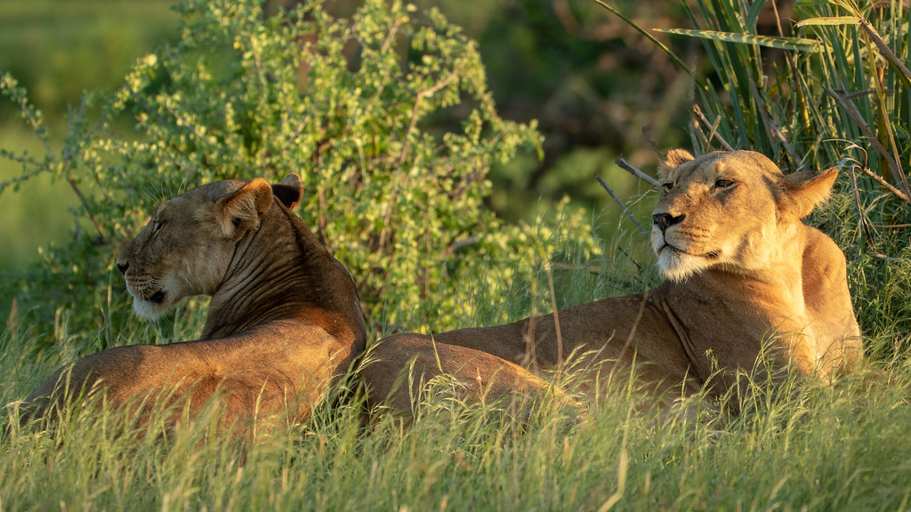
Ishasha Wilderness, Queen Elizabeth National Park
The southern Ishasha wilderness area connects to the south with the Rwindi plains of Virunga National Park (DR Congo). The lowest point has an elevation of 910 meters above sea level. The flora at Ishasha predominantly consists of extensive savanna forest featuring river flat-topped acacia and African fig trees (Ficus cyathistipula), which are favored by lions for climbing. Acacia trees are found along the Ishasha and Ntungwe rivers.
Elephants utilize Ishasha as a pathway during their annual migration across the wider Virunga region. Central African species frequently observed at Ishasha include the Congo buffalo and forest elephants. Ishasha is generally more humid than the Kasenyi lowlands. The average daytime temperature in Queen Elizabeth National Park during the rainy season ranges from 17°C (63°F) to 29°C (84°F), whereas in the dry season, it varies from 16°C (64°F) to 31°C (87°F).
Prominent topographical features in the Kasenyi region
The terrain of Queen Elizabeth National Park was influenced by tectonic and volcanic activities during the rift valley’s creation. Notable attractions include the Katwe – Kikorongo crater lake field, Kyambura gorge, and Kazinga channel.
The Kazinga Channel, Queen Elizabeth National Park
Lake Edward and Lake George are linked by the 45 km long Kazinga Channel. Water transitions from the former to the latter, creating the Lake George wetland, a Ramsar site for endangered avian species, including the shoebill stork. The local tour guides have identified the Big 5 of Kazinga Channel, comprising the elephant, buffalo, Nile crocodile, African fish eagle, and hippopotamus. The likelihood of observing all of them during the boat ride, which can be booked at Katunguru or Mweya peninsula via a tour company or local guide, is substantial.
Mweya Peninsula
From this perspective, one may observe a significant portion of the Kazinga Channel, the lakes, and the remote Rwenzori mountain range. Mweya has the Uganda Wildlife visitor information center, which serves as the park headquarters. Due to its aquatic surroundings, wild creatures such as elephants, warthogs, and hippos frequently graze in the area.
The northern explosion crater lakes
The Katwe – Kikorongo volcanic field spans 180 square kilometers and features more than eight crater lakes filled with both alkali and fresh water, with Katwe and Kitagata hot springs being the most remarkable. Additional lakes in the vicinity comprise Nyamunuka, Kyemengo, Mahenga, Murumuri, and Maseekye.
The Katwe Tourism Information Center, situated at an altitude of 1,067 m (3,501 feet), provides picturesque vistas of the lakes. The creation of these lakes resulted from explosive eruptions caused by the interaction of water with heated magma. The volcanic soils in the region comprise various rocks, including melilite basalts, nepheline foidite, and maars, which exhibit comparatively lower fertility in the rift valley north of Lake Edward.
Lake Katwe
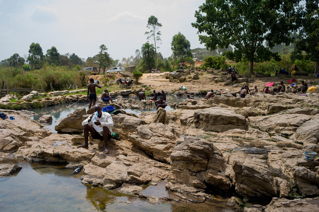
Katwe, the largest, is a shallow saline lake with a maximum depth of 1.6 meters. The depression measures 9 kilometers in length and 2.5 kilometers in diameter. The water has a high alkali concentration above 30 mg/L, establishing it as the largest salt mine in East Africa. The Katwe Tourism Information Center states that the lake holds more than 12 million tons of salt. Salt mining has occurred since the 14th century without any successful industrial extraction. Men primarily conduct the extraction manually, utilizing instruments such as wooden implements and hoes. Individuals possess salt pans privately, and the lake is divided into more than 1,000 pans accordingly. A visit to Lake Katwe provides an opportunity to observe salt mining operations.
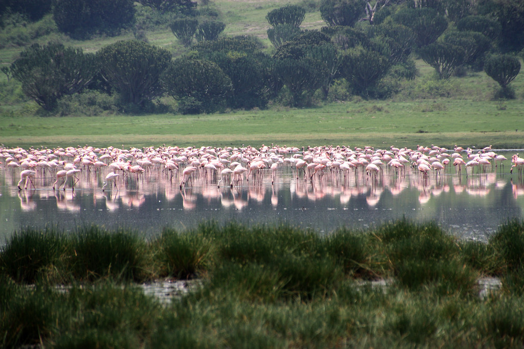
Lake Munyanyange
Adjacent to Lake Katwe lies Lake Munyanyange, which draws lesser flamingos that are recognized for migrating from the saline lakes of Natron (Tanzania) and Naivasha (Kenya). The optimal period for observing flamingos is during the wet season, either from April to May or October to November. Due of elevated water levels, abundant green algae is available for birds to mate before returning to Kenya and Tanzania for nesting. Lake Munyanyange serves as the breeding habitat for pink flamingos.
Kitagata Crater Lake and Hot Springs, Queen Elizabeth National Park
Lake Kitagata and the hot springs are situated in the Sheema district, approximately 95 kilometers (a 2-hour trip) south of Lake Katwe. One can visit the location when traversing the Kasese-Ishaka-Ntungamo-Katunguru road. The lake measures 2.4 kilometers in length and has a maximum depth of 9 meters. The lake is thermally heated by geothermal steam, resulting in hot springs, which signifies the presence of an active volcanic zone beneath.
Two local hot springs, Mulago and Mugabe, have water temperatures reaching 80 °C (176 °F). Kitagata is a dialect of Runyankole Rukiga that translates to “warm water” in English. Local residents assert that the spring water possesses therapeutic properties owing to its elevated concentration of mineral salts, particularly calcium sulfate.
Comparable hot springs are located in Semliki National Park, specifically the Sempeya male and female hot springs. The Kitagata sites are a cultural remnant of the Bachwezi demigods. The mythology states that Kalisa, a prime minister, possessed a human body with a symmetrical form. One side of his body was accessible to touch, while the other remained obscured from view. The presence of a single footprint on the rocks signifies this.
Kyambura Gorge, Queen Elizabeth National Park
The Kyambura Gorge is an 11-kilometer-long, 100-meter-deep subterranean corridor that links the Kazinga Channel to the Kichwamba Escarpment at the northern extremity of the Kasenyi Plains. The gorge encompasses tropical forests that host many primate species, including chimpanzees, red-tailed monkeys, and blue monkeys.
Savanna elephants frequent the gorge and are observable during nature walks. Chimpanzee tracking is the primary activity at Kyambura Gorge, offering a high likelihood of sightings. Kyambura Wildlife Reserve serves as a buffer zone within the Queen Elizabeth Protected Area. A elevated platform overlooks the gorge below. The Kyambura region offers a diverse selection of accommodations that may be reserved via a travel operator.